

He turned seaward from the road at Dollymount and as he passed on to the thin wooden bridge he felt the planks shaking with the tramp of heavily shod feet.…
(James Joyce, A Portrait of the Artist as a Young Man)

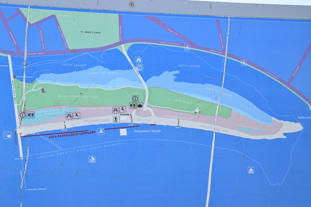
We’re in Clontarf – a mere 15/20 minute bus ride from the city centre – and off for our second walk on the bay. Like Stephen Dedalus in Joyce’s novel, we’ll be heading out onto North Bull Island and Dollymount Strand – beloved of Dublin’s courting couples and learner drivers for generations! No major landmarks to distract here – just a brisk jaunt to blow away the cobwebs (unless, of course, you’re brave enough to don the togs and embrace the Irish Sea!)

A bit of background info before we set off….
Bull Island is usually described as man-made. But that’s not the whole story – I like to think of it as a twist of nature helped along by man.
Here follows a lesson on marine engineering, the power of nature and the creation of an urban treasure.
Sandbanks always caused problems for shipping in Dublin (always that is except for the good old Vikings and their flat-bottomed boats!). At low tide, there was only 6 feet of water on the sandbar at the mouth of the River Liffey and, as ships grew larger and heavier, maritime trade in Dublin suffered. At best, the sands and shallow water were an inconvenience, causing delays for ships that must await high tide to enter and leave. But ships also ran aground or, worse still, were wrecked when unable to run for shelter during a storm.
In the mid 1700’s, a 3 mile long South Wall was built out into the bay.
The natural tidal effect of this wall deepened the mouth of the river – a good thing! But the scoured sand had to go somewhere and was swept to the shallow sandbanks north of the Liffey.
A survey of the bay was required – and who was invited to carry out this work? None other than Captain William Bligh – Yes! – he of Mutiny on the Bounty fame!! Back in England in 1790 after his ‘adventure’ in the Pacific, he accepted the commission for the princely sum of £682!
Bligh was actually a skilled cartographer and in 1801 he produced a detailed report and chart that accurately surveyed the bay and its channels.
It was he who first noted the existence of a small oval sandbar that was permanently dry and stayed in the same place – unlike the tidal sandbars in the bay – which had seemingly appeared due to those shifting currents caused by the building of the South Wall.
Three years later, that small oval patch was described in documents as a considerable stripe with a growth of marine plants.
Bligh suggested that the north wall of the River Liffey be extended out into the bay parallel with the South Wall. This would cut off drifting sands from the north in the same way the South Wall had done and the river, being contained within the walls, would continue to scour the river bed and keep it clear.
The Port Authority didn’t go with his plan and nothing happened for almost 20 years.
By 1818, Bligh’s oval patch had grown to an incredible 5km long spit!
Revised suggestions supported the construction of a North Wall – not parallel to the South Wall – but, over in Clontarf. This stone wall would not stretch directly from the shore – rather there would be a gap and it would start 165m out in the bay.
A wooden bridge, the first Bull Bridge, was erected in 1819 to facilitate the construction of the stone wall.
Started in 1820, the 2.75km Bull Wall was completed in just 4 years. Convicts ferried stone by barge across the bay from Dalkey (tune in to #5 for Dalkey!).
The new ‘island’ attached itself to the Wall and continued to grow as fresh deposits of sand arrived by wind and current.
The walk across the bridge and on to the beach became a huge attraction for Dubliners. When the bridge began to decay, its proposed demolition was greeted with outrage and so it was rebuilt. Access improved further when horse tram services to Clontarf began in 1873, and the new tram line to Howth included stops in the Clontarf / Dollymount area.
Today, its still about five kilometres long but is now roughly one kilometre across. It continues to shift and grow and changes in the shape of the island are observed from year to year.
The island is still connected to the mainland by the Bull Bridge.

The carved granite distance markers guide you along the wall…

OOPS – I know we’ve barely walked 5 minutes but two things of note occur simultaneously – and cannot be ignored! One – incredibly, there’s NO QUEUE at the Happy Out coffee shop! And two – a picnic table becomes vacant right in front of me! Time for coffee and the best toastie ever! Happy Out is Right!!!!


Carpe Diem! – Just look at the queue as we finish up and move on!


Seriously! I can’t spot anyone at all who might be actually taking her photo so what on earth is she doing out there … apart from the obvious posing! (I’m not being bitchy BTW – she stood on that spot for about 20 minutes!)


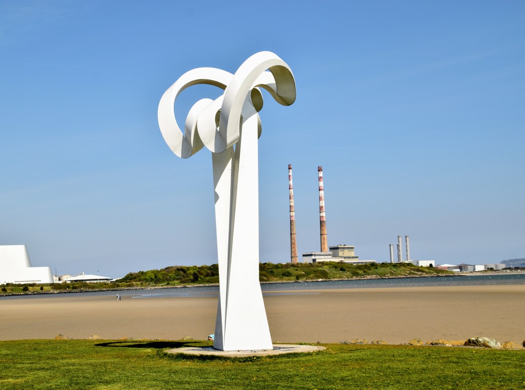
We’re across from the Poolbeg Chimney Stacks – a Dublin landmark (That’s where we’ll be for #3!)


I love the old bathing shelters, added some time in the twentieth century.


Realt na Mara (Star of the Sea) reaches 70 feet into the air. A crowned statue of Mary unusually faces towards land, watching over Dublin’s port workers and seafarers alike. She stands on a globe which is atop a trio of pillars. Her halo of 12 stars is made of Waterford glass.


The last section from the statue to the lighthouse is unpaved. This part is known as a half-tide wall – it is covered at high tide.

As we turn back at the statue, we have the fabulous Dollymount Strand on our right….


Nice as the walk along the wall is, the real attraction here is the beach.
How many capital cities have an amenity like this on their doorstep!! Running the full 5km length of the island, Dollymount Strand is hugely popular for swimming and watersports. Imagine the number of kitesurfers here on a windy day!


We’ll leave Bull Wall and head across the beach – looking back now and again at the ever shrinking Realt na Mara…

That’s Howth Head (from #1 Howth) across the way…

What’s in a name…..
Bull Wall – I’m having trouble with the etymology here. I came across one reference which claims that Bull is another word for strand and that the strands on either side of the River Liffey were known as North and South Bulls. I’ve never heard of a strand being called a bull anywhere else…
but
Clontarf comes from the Irish Cluain Tarbh meaning Meadow of the Bull…… maybe a coincidence..
Dollymount seems to have originated with a house of that name which stood nearby.
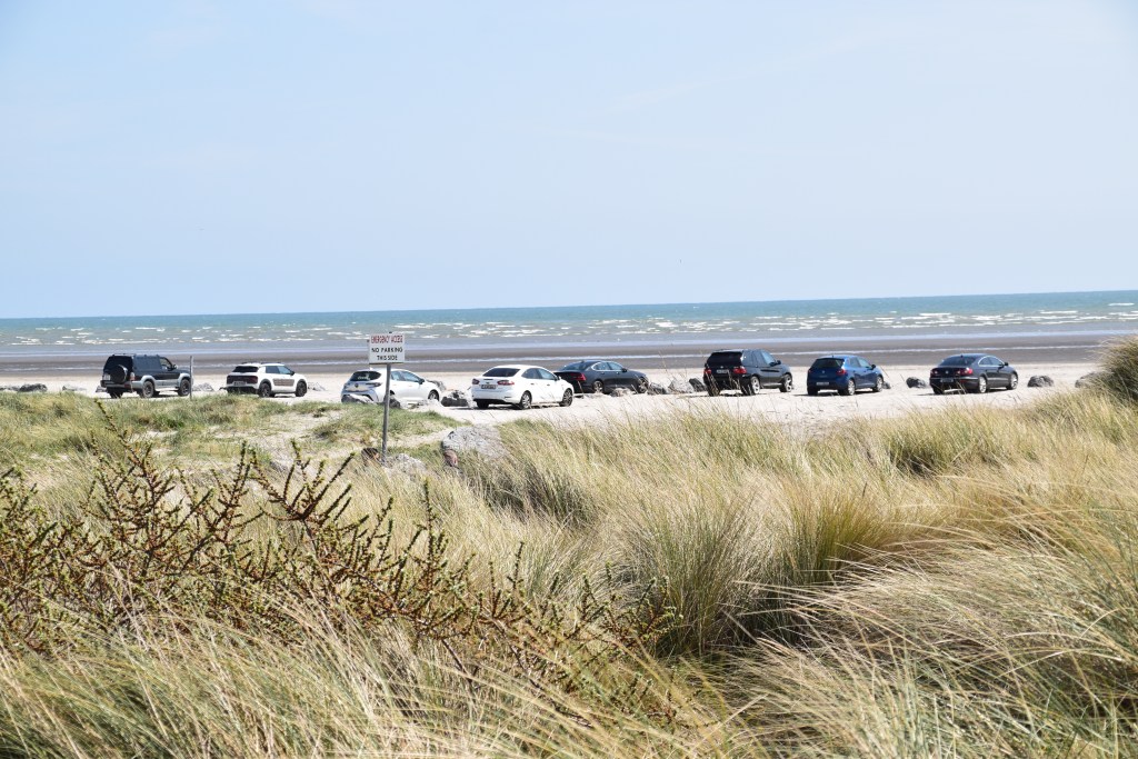
The strand was once fully open to traffic. Picture the scene on a good summer’s day, cars littering the beach, interspersed with picnic blankets, beach toys, sand castles – and holes of course – although you never dug too deeply in case you fell in and got sucked to Australia! Grandad could sit in the car and listen to the football commentary while the extended family teemed around him.
The long stretches of compacted sand made it a great place for locals to practice their basic driving skills before hitting the main roads. Kids, from toddler upwards, started out by sitting on their dad’s laps and steering. I came across a wonderful anecdote about a blind Dubliner who lamented the fact that he would never drive – so his wife brought him on to Dollymount the following morning!
Alas it couldn’t last. The council were no doubt awaiting their chance. The incident cited as the breaking straw is that of a car reversing across a sun bather – apparently it wasn’t so much the actual incident itself as the fact that the emergency services had trouble accessing the accident because of the sprawl of cars…. A 2014 temporary ban has become permanent and drive-on access to the beach is a thing of the past!
There is some parking still at the Bull Wall end of the beach… so a lucky few can still have their picnic out of the car boot on a windy day! Not to mention accommodation for the displaced courting couples in their steamed up cars!


While generations of Dubs were enjoying the spectacular beach and the water, something wonderful was taking shape behind them…
The chain of low lying sand dunes continued to develop at the back of the strand. Salt marshes appeared on the landward side of the island around the intertidal mud and sandflats of the lagoon. These habitats of dune, grass, marsh and mudflat evolved into a sanctuary for an extraordinary wealth of wildlife.
In the 1930’s Bull Island became the country’s first official bird sanctuary.
In 1981 it achieved UNESCO Biosphere Reserve status (the only biosphere reserve in the world located entirely in a capital city).
Depending on the time of year, Bligh’s little oval patch is now home to 8,000 wild fowl, 26,000 wading birds, 180 bird species and 300 species of plants!
For the ornithologists among you: Three winter visitors arrive in numbers that are considered of international importance: light-bellied brent goose, black-tailed godwit and bar-tailed godwit. Other visitors include shelduck, teal, pintail, shoveler, kestrel, oystercatcher, grey plover, golden plover, sanderling, dunlin, Eurasian curlew, redshank, black-headed gull, egret and tern.
Protected species on the island include petalwort (a species of liverwort), marsh fritillary butterfly, at least three species of bat, three moss and several orchids, There are six terrestrial mammal species on the island: brown rat, red fox, field mouse, Irish hare, hedgehog and European rabbit. The beach is a breeding ground for seals and you might spot a harbour porpoise. And then of course there are the insects and minibeasts…!


All this has occurred without human intervention – apart from the construction of the walls of course! There have, however, been a few structural additions on the island over the years:
In 1889, the Royal Dublin Golf Club, then located at nearby Sutton, received permission to lay out a golf course and construct a clubhouse. St. Anne’s Golf Club followed in 1927.

As more people started arriving by car in the 1960’s, another access to the island was deemed necessary. Amidst much opposition, the construction of a causeway (made up of household waste and building rubble) began in 1962. It was situated midway along the island, cutting the mudflats in two. Now the main route to the beach, the long term impact on habitats and species means its existence, almost 60 years later, is still controversial.


The North Bull Island Visitor and Interpretative Centre was built at the end of the causeway in 1986. Here you can learn about the island’s history, its wildlife, and its importance as an ecosystem.

Most of the island (apart from the Golf Club), is the property of Dublin City Council The exception is North Bull Wall and the wooden bridge which are owned by the Dublin Port Company and closed for one day each year to ensure that no right of way is created!!!!
Biosphere reserves attempt to marry the biodiversity of a protected site with a range of human activities.
The challenge here has been to develop the amenities of North Bull Island and balance them with the conservation of its wildlife and rare plants. This means reconciling the recreational interests of swimmers, kitesurfers, walkers and golfers with botanists, birders and environmentalists of every ilk! Park staff contend with snags every day – unleashed dogs that menace nesting birds, or bait diggers, crabbers and shellfish collectors who damage the mudflats. Of course I don’t have to add that the majority of the one million plus visitors per year behave responsibly, totally support the conservation efforts and greatly appreciate what’s on their doorstep.

We’re going to use the causeway to get back up to the main road.


Some people prefer to return back across the beach or through the dunes. But I don’t mind the main road. If the tide is out there’s always something to see on the mudflats. And anyway, I like loops!


At the crossroads at the beginning of the causeway is the Tree of Life. I’ve mentioned it before in posts but this puts it in a location context.
Dublin City Council commissioned sculptor Tommy Craggs to work on a dying Monterey Cypress – thought to be about 200 years old. UK born Craggs worked in forestry before moving into sculpture and has won numerous competitions and awards.
He created the 10 metre piece of art with a chainsaw and was inspired by local wildlife. The ‘Tree of Life’ starts with detailed carvings of sea creatures at the base, then woodland animals and finishes with birdlife at the top.


St Anne’s Park is well worth a visit if you’ve any energy left! It covers a huge area of land on the main road opposite the mudflats and is extensively used by the public (especially if weather isn’t good on the island!). There are lovely woodland areas and water features, dozens of playing pitches and tennis courts, a rose garden and playground. There is a great cafe and, if you’re around on a Saturday, you’ll catch the Farmer’s Market.


And we’re back at the bridge – well done!

He turned seaward from the road at Dollymount and as he passed on to the thin wooden bridge he felt the planks shaking with the tramp of heavily shod feet. A squad of christian brothers was on its way back from the Bull and had begun to pass, two by two, across the bridge. Soon the whole bridge was trembling and resounding. The uncouth faces passed him two by two, stained yellow or red or livid by the sea and, as he strove to look at them with ease and indifference, a faint stain of personal shame and commiseration rose to his own face. Angry with himself he tried to hide his face from their eyes by gazing down sideways into the shallow swirling water under the bridge but he still saw a reflection therein of their topheavy silk hats and humble tapelike collars and loosely hanging clerical clothes.
James Joyce, A Portrait of the Artist as a Young Man
Small Stuff
Getting There:
Dublin Bus 130 from the city centre will bring you to the bridge.
DART – Raheny DART station is about a 15 minute walk to the beginning of the Causeway.
How Long?
Allow an hour to walk the wall and a bit of the beach.
If doing a bigger loop – and including St. Anne’s park – you’ll need up to 3 hours.
The Terrain
It’s a very easy walk. There’s no climbing apart from a scramble through the low dunes!

Facilities:
The are bathroom facilities at both the wall end and causeway end of the beach.
What to Bring:
Nothing major – just the usual common sense stuff: decent walking shoes, a jacket for rain or wind, water, camera, empty bag for your rubbish, bus fare….
Food and Drink
Happy Out – Bull Wall – 10am – 4pm (Toasties finish at 3pm!)
Olive’s Room -St Anne’s Park – 8.30am – 5pm.
Clontarf Road / Bridge junction – there’s a selection of restaurants in the area including Kinara (Pakistani / Eastern ) – and Fishbone


Last time….
We were in lovely Howth

Next time….
Moving south of the river to Sandymount. Tune in to see what this part of Dublin has to offer….
I remember being surprised to see cars on the beach; I had never seen that before. Then I also used it to test drive my car to a potential future owner. I really like this series of shore excursions around Dublin, it’s surely a lesser known aspect by visitors who rush to Glendalough instead.
Not good for cars I know but I LOVE being able to drive on to a beach…. You can just throw EVERYTHING into the car at home and no deciding what to carry!!! Brilliant!
There’s so much around the bay to see and do…. but I can understand the appeal of Glendalough also, especially if its a first visit to the region. But as for any city break, if you return for another visit you don’t have to bother with the ‘major’ attractions again – in Dublin I suppose the Book of Kells and Guinness Storehouse, etc – so it allows time for other stuff…. XXXMarie
A picture perfect day for a walk! And there was coffee!
And the toastie!!!!
What a fantastic walk, and right on the doorstep of the city as you say! Thank you for sharing the history and natural history of this area, and the beautiful views of the beach and island 🙂
Glad you enjoyed it Sarah….you can see how it would take a few days at least to see most of the bay…. you couldn’t possibly fit everything into a day!
Marie, this Dublin Bay piece is wonderful and will trap our lock down walking experiences , with coffee, for times to come.. Thank you for taking the time researching snd sharing .. fabulous work 😘
Thanks Tre for all your support – and you’re the one who told me about the toasties at Happy Out!!! Well done you😋😅
Fascination post thank you. I remember Captain Bligh was set adrift in a open row boat with a handful of loyal sailors By Fletcher Christian, and he managed to navigate it across thousands of miles of sea without a chart. Clearly a very capable man.
In movie of course, Christian was always played by a screen idol – Clark Gable, Marlon Brando, a young Mel Gibson…. Bligh was never going to get anyone’s sympathy up against that lot!!!😅😅
Another excellent post Marie and thanks for the history lesson on William Bligh. He was so much more than a tyrant. Love the coastal scenery. We always inteded to get out to Howth, but the relatives were calling. Stay well and thanks for sharing. Allan
Apparently Bligh was the cause of 3 mutinies in his career!! Definitely a candidate for leadership training!!
The city is certainly in a great location – we’re very lucky.
Hope all well with you Allan – things opening up here a bit which is very welcome. XXMarie
I am delighted to see my old haunting grounds through your wonderful photos, Marie. After we’ve stopped by the Red Stables Food Market at St Anne’s Market every Saturday, we would afterwards go for a walk around the Bull Island. Once we crossed the famous wooden bridge, that links Clontarf and the Island we would be treated to a world of natural delight. Thanks for sharing and have a nice day. Aiva 🙂 xxx
Wasn’t it wonderful, as city dwellers, to have so much on your doorstep!!
Hope today’s rain hasn’t swept Sligo away!! Dreadful here!
Marie. Fantastic information and photos and I feel soooooo lucky to live in this area 👌👌. Nora
I can’t believe how much there is around the bay Nora…. I was originally going to do just one post – summarizing the highlights – but I couldn’t do it!!! It just kept growing! Glad you enjoyed. XXXMarie
How wonderful to have such a superb piece of coastline so close to a city as full of life as Dublin. That walk reads like a great day our before you close the pub door and sup a well earned pint or two…
You can easily justify a feed of pints after that walk!!!😅
Terrific post, Marie and your research does you proud. I’ve learned so much about a part of Dublin that i never gave much thought to, so thank you for that. And what great photos – including the lady in the sea (sure she wasn’t taking a timed selfie)? I’d forgotten just how lovely The Strand was.
Thank you as always Mari for your support. I’m actually enjoying rooting out the info – I’m learning loads myself. No idea what she was at!! – I guess this is a generational thing!!!😅
What a lovely post! I so enjoyed reading it and hoping to visit soon!
A long way from Wyoming but I hope you make it some time!!
It looks so beautiful and I particularly like the Tree of Life. Thanks for sharing Marie 🙂
The tree is beautiful – a great attraction – kids love it….. XXXMarie
Fascinating stroll with lots of detail and history. Thanks for taking us along!
Glad you joined me!! XXXMarie