
I bet you didn’t realise that Ireland, hanging there on the edge of Europe, is the 20th largest island in the world. This makes for quite a bit of coastline. Of course the actual length of that coastline is another matter (and all depends on who’s doing the measuring!!) but it’s generally acknowledged to be around 3200kms.
No part of the island is more than 100kms from the coast and over half the 5 million population lives within 10km of it so to say we’re influenced by the sea is putting it mildly! And of course its importance to our economy cannot be overestimated, be it livelihoods on the sea itself in fishing, aquaculture and related industries in our ports, or its huge significance in the tourism and recreation sectors.
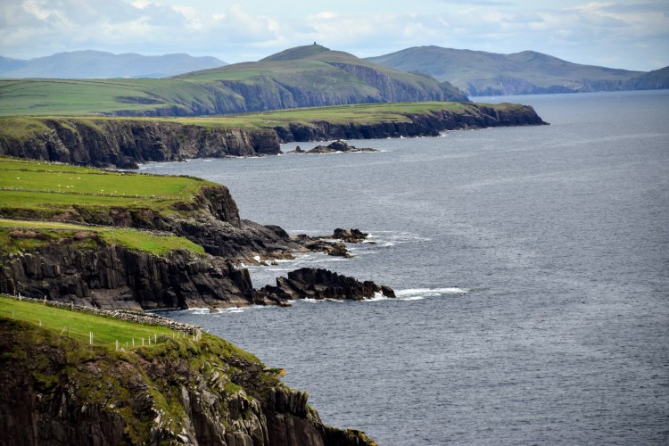
Our shoreline is anything but homogeneous – the bashing of the Atlantic on the west coast has produced a very different landscape to the more sheltered east where the Irish Sea separates us from our British neighbours. But from our dramatic cliffs to our sandy beaches, its all stunning…..
The Cliffs of the West Coast


A few of our sandy beaches…..


Of course not all beaches are massive – there are lots of lovely little coves to enjoy…


There are rare features …..
The karst region – The Burren….

…. the 40,000 odd basalt columns that make up the Giant’s Causeway….

…and more common features….
…. arches and stacks galore….


….headlands, caves and bays…


We’d never let a little thing like weather interfere with our water-based activities….


Never too young to get started….


And if you don’t fancy getting your feet wet….


…there are wonderful driving routes….

…..and you’re never far from a coastal walk…

You never know what you’ll spot along the way…


There are some 80 or so islands off the coast, 20 of which are inhabited….


Coastal towns, harbours and ports have their own beauty…


and then of course there’s the seafood!


Our Stories- as revealed on a coastal drive…
… how far back do you want to go!!!!!!!…….
The Valentia Island Tetrapod Footprints
Discovered in 1991, the prints have been hailed by geologists as the earliest fossilized examples of a prehistoric creature in Europe, and possibly in the world. Thought to date from Devonian times – somewhere between 350 and 370 million years ago -the footprints represent the transition of life from water to land – a momentous turning point in evolution. They provide the oldest reliably dated evidence of four-legged vertebrates – amphibians – moving over land. The Valentia trackway is the most extensive of only four Devonian trackways in the world (there is one in Scotland and two in Australia).


The Ceide Fields
In the 1930’s, a local schoolteacher was cutting turf when he uncovered clearly defined walls of stone buried beneath the blanket bog. Excavations revealed an extraordinary site – dating back almost 6000 years – including a system of fields extending for miles under the bog as well as dwelling areas and megalithic tombs which together make up the most extensive Stone Age monument in the world.


Celtic Ireland
The Celts came from central Europe and gradually moved west – arriving in Ireland about 500BC. The country was divided into numerous kingdoms, each with its own ruler.

Christianity
Christianity arrived in the 4th century. It appears to have been readily accepted (based on an absence of martyrs!) and spread from tribe to tribe. While many monastic settlements sought seclusion in the mountains and forests, some monks took to the islands. This monastery on Skellig Michel dates to circa AD800 and the beehive huts were accessed by some 600 stone steps!


Vikings
The Vikings first attacked in 795. But they weren’t just raiders – they founded Ireland’s first towns along the coast.

Viking Quarter, Waterford City

Normans
The first Normans arrived from Wales in 1167 and, in 1171, Henry II established the first English colony. But it was under Henry VIII in 1541 that England and Ireland were united under one crown.
Incredibly, it’s thought that there are some 30,000 castles and ruins of castles in Ireland today – most constructed under Norman occupation.

King John’s Castle, Carlingford

The Spanish Armada
We all remember the highlights: in 1588, the Spanish Armada – some 130 ships – set sail from Lisbon with the intention of meeting up with an army from Flanders and invading England. They were out-manoeuvred by the English in the English Channel which, along with bad weather, caused them to scatter towards the North Sea. The only means of returning to Spain was around Scotland and Ireland. Caught in violent storms, up to 33 ships were wrecked off the Irish coast that September.
The town of Spanish Point is named for the many soldiers who died here when their two ships sank in the storm (unfortunately for the 74 who made it to land, they were all executed!)


Martello Towers
By the beginning of the 19th century, there was the fear of invasion by Napoleon. Martello Towers were constructed along the coast in 1804. Numbering 45 – 50, they cost about £2,000 each – a substantial sum in those days!

Martello Tower, Seapoint

The Great Famine
By the mid 1800’s, a large part of the population lived on potatoes and buttermilk which an adequate enough diet until the potato blight hit the country in 1845. An estimated one million people died over the following years and another million fled the country (many dying on board the coffin ships). In the west of Ireland in particular, the landscape is littered with deserted homes and settlements, many from the famine era.

Transatlantic Cable
Efforts began in the mid 1800’s to link Europe and North America but distance and depth presented formidable challenges. Finally, in 1866, a cable was laid the full 1686 nautical miles between Valentia Island and Newfoundland. Of course, this wonderful new service was not affordable for all – the initial rate was $1 per letter when the monthly wage for a labourer might be $20. The cable maintained its importance right up to the 1960’s when the first communication satellites offered a serious alternative. In 1966 the Transatlantic Cable Station on Valentia Island closed its doors for the last time.

RMS Titanic
Construction began in the Harland and Woolf shipyard in Belfast in 1909, employing some 14,000 people. The ship embarked on its ill-fated maiden voyage in April 1912.


Transatlantic Flights
On 9th July 1939, Pan Am’s flying boat the Yankee Clipper landed at Foynes in County Limerick to become the first commercial passenger flight on a direct route from USA to Europe.

Seaplanes at Foynes, July 1938
(Photo credit: National Library of Ireland on The Commons on VisualHunt.com)

World War II
Huge stone ÉIRE signs – all numbered – were constructed in the early 1940’s to allow World War II pilots know they were flying over Ireland which was a neutral country (of course they also acted as navigational aids for Allied airmen).

Éire 71 – Sliabh League, Donegal

The ‘Troubles’
The Northern Ireland conflict which lasted some 30 years from the late 60’s to 1998 has left a society dealing with a number of issues but a visit to the cities of Belfast and Derry gives one a chance to explore the region’s history.


Dublin
And let’s not forget Dublin – Founded by the Vikings in 841, they called the new town Dubh Linn (Black Pool) after the nearby dark pool where they moored their boats. Our capital city may be a major international technological hub nowadays but this is still the city of writers and musicians, Georgian squares and that perfect pint of Guinness!!

Part of Dublin Bay

And one yarn before I go…….
We love being an island nation. However, we were connected to Scotland for a while at one time …..
The giant Fionn Mac Cumhill was one of our great warriors and leaders. When another giant – Benandonner, across the Irish Sea in Scotland – threatened Ireland, Fionn, in a rage, began tearing up great chunks of the northern coastline and hurling them into the sea. This gave him an idea! He decided to keep going and create a pathway over the sea to reach his enemy. However, Fionn had underestimated the size of Benandonner – he was by far the bigger giant!!
When Fionn saw what he was up against he retreated unseen to Ireland with Benandonner hot on his heels across the newly formed path. Fionn’s quick-thinking wife – Sadhbh – disguised her husband as a baby. When Benandonner arrived and saw Sadhbh with the ‘baby’ he realised that if Fionn’s baby was that size, the father must be absolutely HUGE! Benandonner rushed back to Scotland, tearing away as much of the path as he could to put as much distance between Fionn and himself as possible.
And that, my friends, is how the Giant’s Causeway was formed!

Seriously, you should work for the tourist info people!! Your posts make me want to get to Ireland ASAP!!
That would be a very nice job indeed! I’d be quite happy wandering the country – just need bed, board and petrol!
You are convincing me that I must come back to Ireland, and looking at the beauty evidenced in your photographs, I imagine the mixed feelings of my ancestors who left for a “better” life in New Zealand.
Imagine how far away New Zealand was!!! Most went to the US and England and some to Australia – we don’t hear of many who left here for New Zealand… Even today it’s a bit of a challenge!!
Your post also inspired me to research the Tetrapod Trackings in Australia,- so thanks also for the education.
Good stuff! I knew nothing about the tracks either until we visited Valentia during covid…
…. and as my tee-shirt bought from the old Titanic Museum says “It was all right when it left here”. I agree with Bernie, you are a great asset to Irish Tourism. Great information and illustrations as usual.
Great slogan isn’t it!!!😅 😂 🤣
I’m certain that the Tourist Board no nothing of my existence but thank you😘
Lots to see! I want to see some cute Puffins.
Aren’t they just gorgeous! Saw them early August – another week or so and they’d have left for the winter…
A gorgeous tour of Ireland Marie.
Thank you – I had to cut it back in the end – there was just so much stuff I could have included!
Fantastic, Marie! This is a wanderlust inspiring post, and I loved reading the history of your beautiful country. Mike and I would love to travel there one day and visit every one of the “stars” on your maps.
And you will!!!!
I agree with previous comments that you should be writing for the Irish tourist board! You cover so much ground in this post with beautiful landscapes, interesting tales and lots of history. I never knew about those Eire signs, nor stopped to consider the fact that the country was neutral during WWII.
The signs are great – a lot are in disrepair but some local communities have put them back together and freshened them up a bit. Many are in stunning tourist locations so are an attraction in themselves nowadays.
Thank you for your photos and descriptions of one of my favorite places on earth! I only got to see a small part of your beautiful Ireland when we traveled there a few years ago. I recognized some of the places in your photos and would love to return to see all of the places I missed. I love the story of the Giant’s Causeway!
U’m delighted that you recognised a few places – I love spotting familiar scenes in other people’s blogs! It’s a great story isn’t it…. every word of it is true of course!!!
It’s just so beautiful Marie, I think I could spend months in Ireland exploring
We were in a little fishing port this morning – 2 hours from us – the first time for both of us – there’s so much here that we’ve yet to see….
There’s so much in this article, it’s a good description of Ireland with its dense history in every corner of the landscape.
Thank you – I started off with a blog just about cliffs and it mushroomed from there!!
What a great exposition and overview of Ireland. Your globe-trotting hasn’t blinded you to the beauty and endless interest of the country. A great post.
Thanks Roy – we’d been concentrating on globe trotting all right but Covid helped reignite an appreciation of what we have at home. We’ve revisited places we haven’t seen in years but have also spent time in parts of the country we don’t know that well – it’s actually been great….